Sunday, May 17, 2009

Mt Pulag ....... again???

Text & Photos by Aireen Navarro


Just when I thought I'm 'retiring' from all backpacking/trekking adventures; a friend invited me to a Mt. Pulag climb!!! My last backpacking adventure was at the same mountain, exactly 6 months ago (Oct 2008). That trip took its toll on me -- especially the freezing temperatures. On my way down, I kept telling my friends that it's my last backpacking trip....I was ready to hang up my boots and stick to the beach.


BUT.....I'm ready to take back my 'retirement announcement'! There's something about Mt. Pulag that makes it hard to say 'no' to. It had actually taken me 8 years before I finally got to the summit. My backpacking adventures started way back in 2000. Since then, I've been keen on climbing Mt. Pulag...and this finally happened last year!


We set off from Manila on the evening of Oct 17th via a 6-hour bus trip to Baguio City. Got to the city of pine trees at 0600H on Oct 18th, ate breakfast, did our last-minute shopping for food & water supplies, then we're off to a 2-3 hour drive to Kabayan, Benguet via Ambuklao with our hired jeepneys owned/driven by very skilled local drivers who are very familiar about the intricacies of driving on narrow winding mountainside road networks.


The view around Ambuklao Dam is beautiful! It's approx. halfway to the DENR office where a mandatory registration/briefing's conducted. This usually takes approx. 40 minutes up to an hour, depending on the Q&A portion. Last-minute shopping and thick blanket rentals are available.

The DENR office emphasizes the COLD, the unpredictability of drastic climate changes up there, ‘unpredictability’ as the name of the game and the fragile ecosystem which requires us to stay on established walking trails and use designated ‘loos.’


From there, it's a really BUMPY road to Ambangeg Ranger's Station where local guides and porters wait. We’re talking about stiff hands after the drive – stiff from tightly holding on to our jeepney’s handrails so as not to fall off. Top loading (riding on top of the jeepney) is no longer allowed on this last jeepney-ride leg.


To protect and promote local livelihoods and the Mt. Pulag National Park, local guides/porters are mandatory and depend on the number of visitors. More information from this weblink (http://pawb.denr.gov.ph/protected/mt_pulag/pulagvik.htm). Even if you're accompanied by seasoned guides from Manila, you still need to hire local guides and porters as they intimately know the ins & outs of the area, including its unpredictable weather patterns.


After we had our lunch and last-minute preparations at the Ranger's Station, we set off to the Grasslands Camping Ground 2 which can be hiked in less than 4 hours if you're physically fit or a seasoned hiker/backpacker. After less than an hour of trekking via the easiest trail out of 3 trails from Benguet (we went via Ambangeg), it rained. Hard. DOWNPOUR. My extra-large trash bags effectively served as my poncho/raincoat. Thank God the rain stopped and I was still ‘mostly’ dry. Otherwise, I'd FREEZE before I even get to the camp site.


That was a grueling hike! But the vegetation / terrain made it very interesting. A place to rejuvenate the senses - fresh air! Everything's green - different shades of greens and browns. My heavy backpack took its toll on me. I was one of the last groups to make it to our campsite --- after almost 5 hours of hike/water break/photo stops/hike! I was getting worried that I might miss the sunset! That thought was a good way to push myself to get moving!


Most tents were already set up with the sun setting down by the time we got to our camp site. Good thing I was able to catch the sunset! The explosion of colors and pockets of ‘sea clouds’ made the loooong day worth it! Freezing hands aside, I braved the COLD winds and took photos before taking refuge inside our assigned tents. By the time I changed into dry clothes & socks, my extremities were already numb from the COLD.


We are talking about freezing temperatures. The kind that makes your nose drippy the whole time, the kind that makes you want to just roll into a fetal position, all covered by layers upon layers of skull caps, shirts, jackets, pants, socks and scarves inside your sleeping bag. The kind of cold that even taking a pee is an ordeal as it entails going out of your tent and face the COLD. I had to forcibly drag myself out of our tent to eat dinner. Food needed for sustenance for our very early morning hike to the peak of Mt. Pulag.


The freezing temperatures woke me up every hour. Eyes and head hurting from the cold, we finally heard our wake up call. We set off at 0330H on Oct 19th, estimating a 2-hour hike to get to the peak of Mt. Pulag before the sunrise. That was TOUGH!!! Ever hiked amid thick fog? Barely seeing what you’re stepping on, where you're at? Voices carried away by strong, freezing winds? There was a time when I was separated from my group. That was scary!!! Howling winds slapping on me from different sides, barely able to see with my weak headlamp, covered in clouds (drizzly feel to it), seeing ice crystals on my eyelashes, my shouts were pointless. I stayed put on the trail and waited until another group walking at a slower pace, reached me.


FINALLY, we reached the summit of Mt. Pulag!!! We missed the sunrise! That was a bummer but at least I didn’t miss that much coz the people who got there before sunrise told us they didn’t see a spectacular sunrise as they’d hoped for as it was covered with clouds and fog. I got to the summit at 0615H. It’s like a party at the summit!!! Everyone simply HAPPY & jumping, shouting at the top of their lungs. I finally made it to the 2nd highest peak in the Philippines!!!


At 2,922 meters above sea level, reaching the peak of Mt. Pulag is a heady experience!!! Standing up there, literally ‘walking on the clouds,’ turning around with a 360 degree view of the ‘sea of clouds’ – WOW!!! I was practically right at the middle of where the borders of 3 mountainous provinces meet: Benguet, Ifugao and Nueva Vizcaya. Given the peak’s elevation, it rains most of the year. We got lucky it cleared for a few minutes but we still got wet with the clouds & strong freezing winds slapping around us from all directions.


We took refuge behind dwarf bamboos endemic to the Mt. Pulag National Park. Another endemic vegetation is the Benguet pines which were all over our camp site, at a lower elevation. There were hundreds of other plant species with more yet to be documented. Of course, it’s also home to over 33 different species of birds and several mammals under the ‘threatened species’ list: long-haired fruit bat, bowet, giant bushy-tailed cloud rat, dwarf cloud rat and Philippine deer. I didn’t see any of these mammals though. Maybe in my next adventure to Mt. Pulag???


The hike back to our camp site was sad. It’s like saying goodbye to a very special place.

By 0930H, we all had breakfast and were just ‘sunning’ ourselves, looking up a brilliant blue sky and clouds, serenaded by wind & tree songs.

Before we know it, we packed up and hiked back to the Ranger’s Station. Every step away from our camp site was a ‘farewell step’ to my backpacking days….


But, now that a friend invited me to a Mt. Pulag climb, I might meet up with the local friendly guides again!!! We’ll see :)

Itinerary:

Day 1-2 October 17-18, 2008

2300H Assembly Victory Liner Cubao
2345H Loading Bus
0000H ETD Manila to Baguio
0600H ETA Baguio
0700H Breakfast
0830H ETD Baguio to Ranger’s Camp
1030H ETA DENR
Briefing and Orientation
1230H ETA Ranger’s Station
Lunch
1330H Start Trek (Ambangeg Trail)
1800H Prepare Dinner
1930H Dinner
2045H Socials
2200H Lights off


Day 3 October 19, 2008

0330H Wake up Call Summit
0530H ETA Summit
0700H ETD Summit
0830H ETA Base Camp
0900H Breakfast
1000H Break Camp
1030H ETD Base Camp to Ranger’s Station
1330H Prepare Lunch
1400H Lunch
1400H Wash Up
1430H ETD Ranger’s Station to Baguio
1830H ETA Baguio
Buy Souvenirs
2100H ETD Baguio
0200H ETA Manila (Oct 20)

Tuesday, March 10, 2009

The Ultimate Flying Safari: Okavango Delta - Savute/Linyanti - Livingstone

~ Text & Photos by Aireen Navarro ~

African Safaris are the epitome of adventure!!! Safaris evoke images of vast open plains, pristine wilderness, a place where animals roam freely and have their own migratory patterns unhindered by any human interventions.

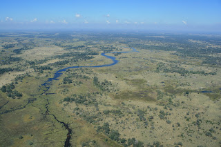
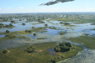
Exploring Africa, specifically the southern parts, are best done flying from one game area to another area, giving you spectacular aerial views of untouched savannas, deltas, open plains, dambos, miombos, deserts, sand dunes, lakes, water holes where hundres of elephants and hippos usually congregate, herds of wild animals roaming vast open permanent and seasonal floodplains, waterways, marshlands, grasslands, mopane woodlands, riverine areas.....the list goes on and on...... If you can, go for one flying safari at least once in your life --- it's simply awesome!!!!

I can confidently vouch for this! Instead of going on long drives (self-drives), go for flying safaris. Enjoy southern Africa from the air, then when you get to your safari camp - focus on gameviewing activities and learn more about wild animal movements/behaviors. I had the chance to do this last year (May 2008), thanks to my job :)

In a span of a few days, I was able to explore Botswana's Okavango Delta before moving up to the nothern parts of the country where the Linyanti and Savute Channel are, and finally ending it in Livingstone, Zambia.

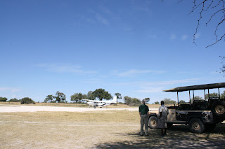
We took off from Maun onboard a Cessna Caravan (13 seater aircraft). We're cruising low and sometimes got glimpses of big game roaming around.....like an elephant bull browsing....a herd of buffalos moving towards water/food source.....even a giraffe taking refuge under a tree when the sun's at its hottest during the day....hehehe....

We first flew into the southern Okavango Delta and landed at the Chitabe Concession which borders the Moremi Game Reserve. The two safari camps in this concession which comprises 28,000 hectares is owned by the Hamman couple (Dave & Helene) who co-produced the book 'Running Wild - Dispelling the Myths of the African Wild Dog.' It's right in between two river systems in the Okavango - Gomoti on its eastern side and Santantadibe on its west.

After a few hours on the ground, we flew to the north-western part of the Okavango Delta where the Jao Concession is located. Located directly the Delta's pandhandle, gameviewing is fantastic - just imagine having 60,000 hectares of private land with very few people on it (just safari camp guests and camp staff).

Then off to the Vumbura Concession where we stayed for three days. The most unique as it's located at the northernmost of the Okavango Delta, making it the remotest safari area comprising over 6o,000 hectares with just 3 safari camps. I LOVE this concession!!!

Then too soon, our stay ended and we moved on to the heart of the Okavango Delta, flying over Chief's Island (Moremi Game Reserve) where the gameviewing is legendary and the favorite destination of wildlife photographers. Many wildlife documentaries have been filmed here. Mombo and Little Mombo Camps proudly 'lorded' over the area when we landed/took off from its airstrip.

We finally left Okavango and flew all the way up north, flying over the Linyanti Concession (Linyanti Wildlife Reserve) where the Savute Channel snakes around & through it. It comprises 125,000 hectares and is bordered by the Linyanti River (east to west) and the Caprivi Strip of Namibia. It only has 3 safari camps -- very exclusive indeed!

We had to land in Kasane for immigration formalities, before setting off to Livingstone, Zambia.

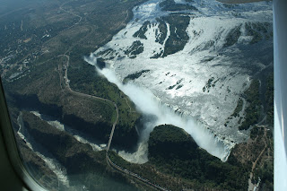
We flew over the upper Zambezi River, then flipped around Victoria Falls which sits in between Zambia and Zimbabwe.

There's no other way to view this Falls but from the air!!!

We're talking about 1,708 meters wide of thundering water --- 'Mosi-oa-Tunya or The Smoke that Thunders' indeed!!!

Monday, March 9, 2009

Whaleshark Interaction in Donsol, Sorsogon

~ Text, Photos & Videos by Aireen Navarro ~

Whaleshark interaction in Donsol, Sorsogon.....wow, it seemed scary and impossible at first. Swim with the giants of the ocean - literally the biggest fish and a shark at that!!! But, don't be fooled by its name, whalesharks or 'butandings' as known locally, are the gentlest marine species....that is, as long as you stay out / away from its powerful fins :)

The whalesharks in Donsol first gained popularity in 1997. In fact, I've heard about it in one of my classes. We have this 'Tourism Development' course which gave us an opportunity to do field research for 1-2 weeks (field research aka enjoying out-of-town trips with classmates!!!). Unfortunately, my group didn't go to Donsol. another group did BUT they didn't see the whalesharks!!! Well, they were there for just 1 weekend....

But still, that's a loooooong bus ride from Manila to Donsol and end up not seeing one whaleshark...we're talking about 10-12 hours or more (bus since as students, we can't afford to take the plane to Legazpi to shorten the road trip to 2 hours). What does it mean? It simply means that wild animals are always unpredictable and never a guarantee that you'd see them -- it's always a 'hit or miss' scenario....

After college, I've been longing to go to Donsol but it was only in April 2005 that I finally had the chance!!! We hired a van (equally split the bill) then set out from Manila on a Friday evening, after work. That's an 'all-nighter' drive!!! The driver was a bit slow so we ended up arriving at around lunchtime the next day. Well, at least we're still in one piece!!!

We headed to the Tourism Office, registered and took note of the rules and was introduced to our BIO (Butanding Interaction Officer). Once all formalities are over, we're all set to go!!! The water's clear but a bit murky, thanks to the zooplanktons and cloudy sky. We spotted several whalesharks!!! When it's spotted, better be prepared to jump off the banca/boat at ALL times. You just have to wait for your BIO to shout 'JUMP'!!! Here are very short videos I was able to take while trying to keep up.......

Whew!!! They're huge and FAST!!! You have to move swiftly or you'll lose them!!!


There are guidelines/rules that we also need to follow while interacting/swimming with the whalesharks -- the assigned BIO ensures that these are followed. If you're a slow swimmer, better let the BIO know about it -- if he's nice, he'd do all the 'swimming' part and just pulling you along :)


First round on a Saturday afternoon was AWESOME!!!!! We loved it so much we arranged for another interaction the next morning. FYI: The best time for whaleshark interactions are during early mornings -- calm and clearer as well and it's usually at these times that a lot of whalesharks 'feed' on planktons/krill -- so why not join the party??!!!

Our Saturday evening was spent hanging out on the beach, stargazing. It was low-tide so we walked around a bit and saw weird sea creatures......what do you think those are???

Early Sunday morning, we headed back to the Tourism Office where all boats/BIOs are stationed. We then set off and indeed, we saw LOTS of whalesharks. We couldn't keep up though......but it's really wonderful......

We even had a huge BONUS!!! Out in the distance, we saw hundreds of dolphins!!! Amazing!!!


We all got soooo excited and tried to follow/go as near as we can. Of course the dolphins were too far off, but that was just wonderful and a HUGE surprise. According to the local firshermen, there are no more dolphins in the area, dolphins had become wary of fishermen who used to hunt them......


Then, the excitement ended too soon :( I didn't want it to end but hey, one needs to find a balance and both good and bad times end.....It just so happened that good times ended. Getting off our boat, we saw lots of very colorful jellyfishes. The kids were playing with them......they're not afraid of its sting!!!!

We stayed for a while, taking photos before finally leaving Donsol....

What's a trip in the Bicol Region without a photo stop at the Cagsawa Ruins where the Mayon Volcano provides a panoramic backdrop? We took lots of photos off course and went shopping for souvenirs :)


That weekend was too short......hopefully I'd be able to go back and spend 3-4 days or more....maybe combine whaleshark interaction with a trip to neighboring Ticao Island for the manta rays?........we'll see.....

Note: Sorry folks, the videos are very short and amateurish....hehehe...I used a digital camera with very limited zoom, so go figure :)